نقد و بررسی : نرم افزار نقشه برداری سرویی مستر Survey Master
نرم افزار اندرویدی سرویی مستر Survey Master
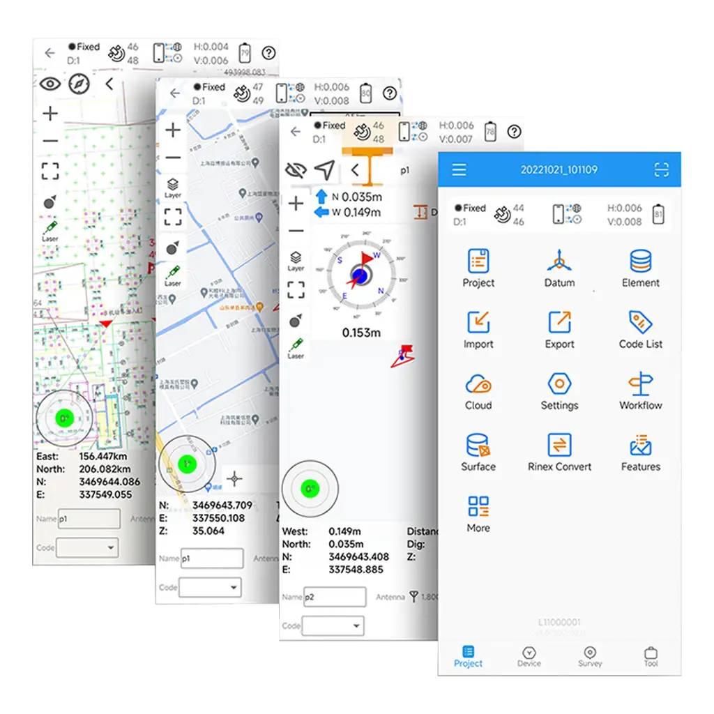
نرم افزار نقشه برداری سرویی مستر Survey Master یک برنامه کنترلر اندروید به طور خاص برای استفاده حرفه ای با گیرنده های GPS/GNSS RTK ساخت کامنو سینو جی ان اس اس ComNav SinoGNSS طراحی شده است. یکی از نقاط قوت کلیدی Survey Master در مجموعه جامع ابزارها و قابلیتهای آن نهفته است که به کاربران اجازه میدهد، تا کنترل RTK، جمع آوری داده های GIS، و طراحی و چیدمان جاده ها را در یک رابط بصری یکپارچه کنند. این امر آن را به یک راه حل ایده آل برای متخصصان صنعت نقشه برداری و نقشه برداری و همچنین برای مهندسان، معماران و برنامه ریزان شهری کاربران محصولات SinoGNSS – ComNav تبدیل می کند.
توجه : از ورژن 3.4.1 به بعد کمپانی SinoGNSS – ComNav نرم افزار سرویی مستر SurveyMaster را فقط با لایسنس رجیستری برای کنترلرهای اندرویدی تولید خود یا خرید لایسنس به صورت مجزا برای هر دستگاه بر اساس Device ID ارائه می نماید.
Regarding Software Registration
In Version 3.4.1
- Users with ComNav controller enjoy automatic permanent registration, unlocking all features, including NMEA Device function.
- ComNav receiver users can use the software normally, only the NMEA Device feature is disabled and requires registration to enable.
In Future Versions, Starting from V3.5.0:
- Only ComNav controller users get automatic permanent registration, accessing all features.
- Other users require a registration code for normal usage.
- ComNav provides registration codes to partners, contact sales for more information.
Others
- Fixed some bugs
چرا برنامه Survey Master را انتخاب می کنید؟
برنامه کاربردی برای پروژه های نقشه برداری با گیرنده های ایستگاهی کامنو است.
Survey Master برای کمک به نقشه برداران در انواع پروژه های نقشه برداری زمین و مهندسی راه استفاده می شود. با استفاده از برنامه Survey Master در دستگاه های هوشمند یا تبلت اندرویدی خود، می توانید به طیف گسترده ای از ویژگی های حرفه ای برای گیرنده GNSS خود بدون نیاز به کنترلرهای گران قیمت دسترسی داشته باشید.
سازگار با تجهیزات SinoGNSS.
همراه با بسیاری از سیستم های مختصات چند کشوری که از پیش تعیین شده، پیش بینی ها و غیره. از فایل های Geoid و Grid پشتیبانی می کند.
نرم افزار نقشه برداری سرویی مستر Survey Master قابلیت درون ریزی و برون بری فایل های CSV، DAT، DXF، SHP، KML، GPX، TXT و بسیاری از فرمت های دیگر را دارد.
راه حل برد-برد شما
ویژگی های قدرتمند و رابط کاربری آسان
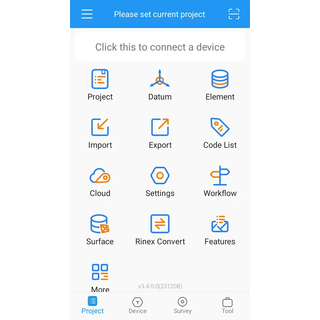
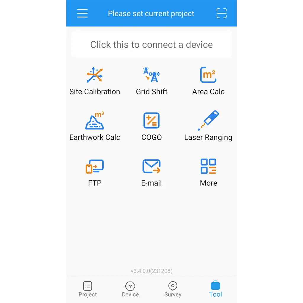
نرم افزار نقشه برداری سرویی مستر Survey Master یک نرم افزار قدرتمند برای جمع آوری اطلاعات است. طراحی همه کاره و عملکردهای قدرتمند آن به شما امکان می دهد تقریباً هر کار نقشه برداری را سریع و آسان انجام دهید. میتوانید سبک نمایشی را که ترجیح میدهید، از جمله فهرست، شبکه و سبک سفارشی انتخاب کنید. Survey Master عملکرد آسان با تعامل گرافیکی از جمله محاسبه COGO، اسکن کد QR، انتقال FTP و غیره را فراهم می کند.
قابلیت اتصال
اتصال سریع
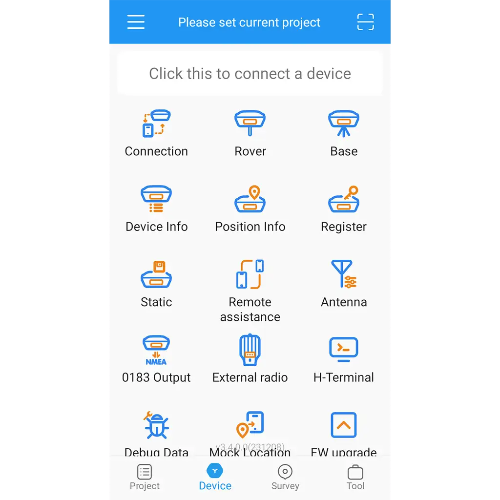
می تواند با بلوتوث و وای فای به GNSS متصل شود. می تواند با استفاده از اتصالات بی سیم، دستگاه را به طور خودکار جستجو و متصل کند.
طراحی راه
محاسبات سریع
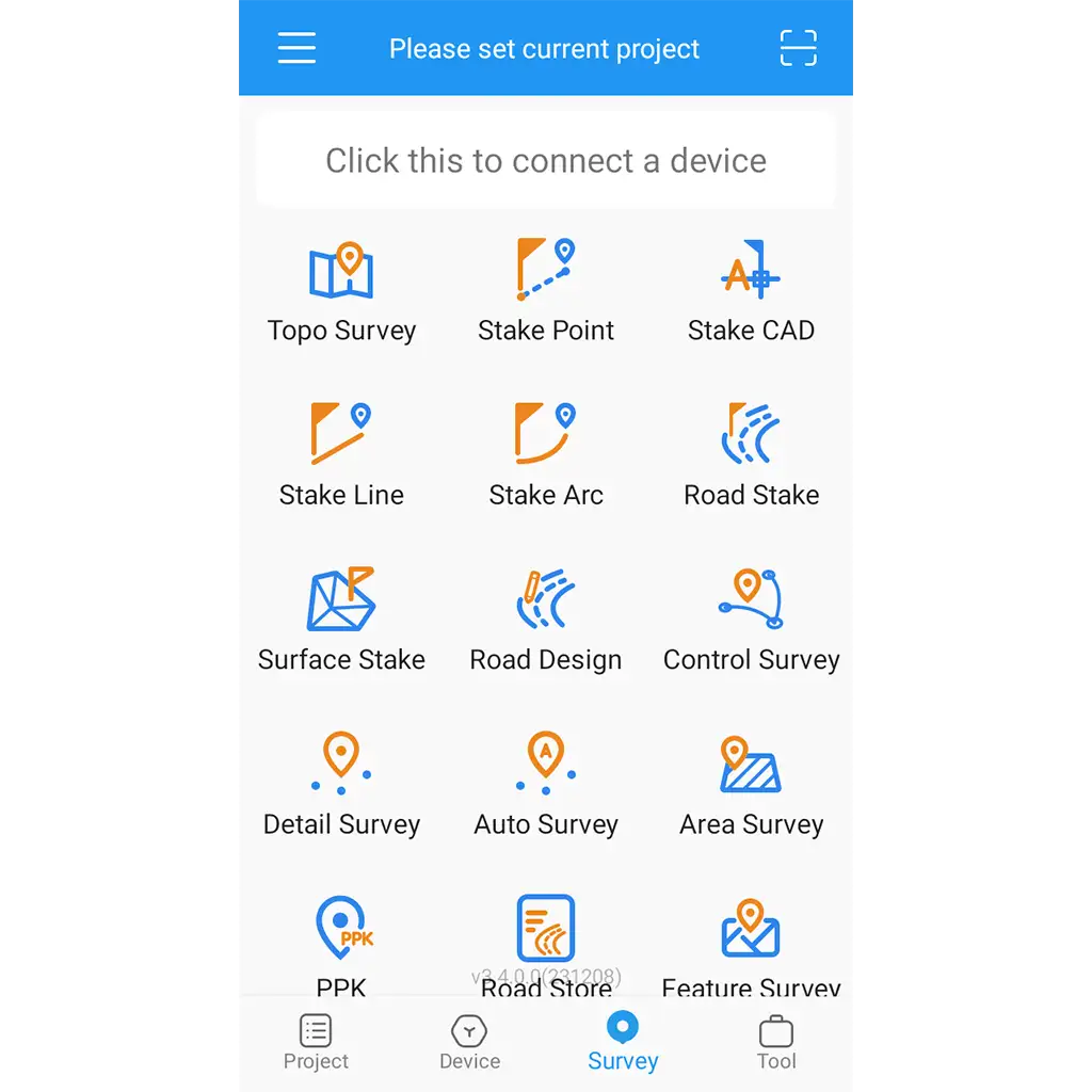
این دارای یک طراحی حرفه ای کامل جاده و ویژگی ترسیم است، بنابراین شما می توانید داده های پیچیده جاده را به راحتی محاسبه کنید.
هشدارهای صوتی
درک بهتر
عملیات مهم با هشدارهای صوتی همراه است: اتصال ابزار، راه حل موقعیت یابی ثابت GPS و جابجایی.
ویژگی های نرم افزار نقشه برداری سرویی مستر Survey Master
1. این نرم افزار عملکردهای قدرتمندی دارد، یک فرآیند عملیاتی هدایت شده را اتخاذ می کند، دارای یک رابط تعاملی دوستانه است، و همراه با دستورالعمل های عملیاتی است تا مشتریان را برای یادگیری سریع استفاده از نرم افزار تسهیل کند.
2. دارای حالت های کاری متعدد و مجموعه های پیکربندی قابل تنظیم است تا کاربران را در راه اندازی سریع وب سایت تسهیل کند.
3. توابع اندازه گیری جاده غنی، پشتیبانی از پیوندهای شکسته، منحنی های مسطح، منحنی های عمودی، ارتفاع فوق العاده، تعریض و ورودی پارامتر شیب. این نرم افزار می تواند به طور مستقیم عرض جاده و ارتفاع شمع لبه را محاسبه کند، و میدان می تواند پر کردن و حفاری را در هر موقعیتی در جاده در زمان واقعی نمایش دهد.
4. این نرم افزار می تواند نقشه ها را در فرمت های مختلف مانند DXF، DWG، SHP و غیره وارد کند و انجام اندازه گیری نقشه را در حین عملیات میدانی راحت کند.
5. از بررسی خطوط برق و جابجایی پایه برج پشتیبانی می کند و به طور یکپارچه با نرم افزارهای طراحی برق مانند Daoheng و Bosch سازگار است.
6. پشتیبانی از چندین زبان، چندین زاویه و واحد طول، که می تواند نیازهای تجاری مشتریان داخلی و خارجی را برآورده کند.
Survey Master Android App
Android mobile application specifically designed for professional use with SinoGNSS ComNav GPS/GNSS RTK receivers. One of the key strengths of Survey Master lies in its comprehensive suite of tools and functionalities, which allow users to seamlessly integrate RTK control, GIS data collection, and road design and layout in a single, intuitive interface. This makes it an ideal solution for professionals in the surveying and mapping industry, as well as for engineers, architects, and urban planners.
Why You Choose Survey Master App
The Most Effective App for Your Surveying Projects
The Survey Master is designed for assisting professionals to work efficiently for all types of land surveying and road engineering projects in the field. By utilizing the Survey Master app on your Android smartphone or tablet, you can access a comprehensive range of professional-grade features for your GNSS receiver without the need for costly controllers.
Compatible with many brands of GNSS equipment.
Comes with preset multi-country coordinate systems, projections etc. Supports of Geoid and Grid files.
Import & export of CSV, DAT, DXF, SHP, KML, GPX, TXT files.
Your Win-Win Solution
Powerful Features and Easy Interface
The Survey Master is a powerful software for data collection. Its versatile design and powerful functions allow you to complete almost any surveying task quickly and easily. You can choose the display style you prefer, including list, grid, and customized style. It provides easy operation with graphic interaction including COGO calculation, QR code scanning, FTP transmission etc.
Connectivity
Quick connection
Can connect to GNSS by Bluetooth & WiFi. Can search and connect the device automatically, using wireless connections.
Layers
Better visualization
Supports online and offline layers with DXF, SHP, DWG and XML files. The CAD function allows you to draw graphics directly in field work.
Road Design
Quick Calculations
It has a complete professional road design and stakeout feature, so you can calculate complex road stakeout data easily.
Voice Alerts
Better Perception
Important operations is accompanied by voice alerts: instrument connection, fixed GPS positioning solution and stakeout.
Survey Master Handbook software
Survey Master software is a special geodetic survey software developed by Geoelectron based on the Android platform ordered by SinoGNSS ComNav. Based on years of market experience and combined with the international mainstream surveying and mapping data collection operation requirements, it integrates RTK control collection, road design and stakeout and other functions. The software has the characteristics of humanized operation process, better graphical interaction, and more powerful functions.
Software features
1. The software has powerful functions, adopts a guided operation process, has a friendly interactive interface, and comes with operating instructions to facilitate customers to quickly learn to use the software.
2. It comes with multiple working modes and customizable configuration sets to facilitate users to quickly set up a website.
3. Rich road measurement functions, supporting broken links, flat curves, vertical curves, superelevation, widening, and slope parameter input; the software can directly calculate the road width and edge pile elevation, and the field can display filling and excavation at any position on the road in real time value.
4. The software can import maps in various formats such as DXF, DWG, SHP, etc., making it convenient to carry out map measurements during field operations.
5. Supports power line survey and tower base stakeout, and is seamlessly compatible with power design software such as Daoheng and Bosch.
6. Supports multiple languages, multiple angles, and length units, which can meet the business needs of domestic and foreign customers.
With Survey Master Android Application, you can survey though Topo survey/Auto survey, Static and PPK modes; edit and stake points/lines. Also this App provides a convenient way to import/export surveying data files, supporting data formats: TXT, CSV and AutoCAD DXF.
Note: Please keep Bluetooth on your phone opened, so that Survey Master and T300 receiver can connect successfully.
HOW IT WORKS
The process is really simple just go through the following steps to get on:
1) Create a new survey project
2) Manage datum systems
3) Connect with T300 GNSS receivers via Bluetooth
4) GNSS surveys (Field data collection)
5) Data files output
Regarding Software Registration
In Version 3.4.1
- Users with ComNav controller enjoy automatic permanent registration, unlocking all features, including NMEA Device function.
- ComNav receiver users can use the software normally, only the NMEA Device feature is disabled and requires registration to enable.
In Future Versions, Starting from V3.5.0:
- Only ComNav controller users get automatic permanent registration, accessing all features.
- Other users require a registration code for normal usage.
- ComNav provides registration codes to partners, contact sales for more information.
Others
- Fixed some bugs
مشخصات فنی : Survey Master
| برند | |
|---|---|
| کشور سازنده | چین |
برای نوشتن دیدگاه باید وارد بشوید.










دیدگاهی ثبت نشده.