نرم افزار نقشه برداری Leica Geosystems IMSLeica Geosystems IMS
تماس بگیرید
بررسی اجمالی محصول
نرم افزار نقشه برداری Leica Geosystems IMS ساخت لایکا سوئیس یک نرم افزار بازسازی صحنه حادثه و جرم مختص نیرو های پلیس و جرم شناس است. سیستم طراحی تعاملی ما، ایجاد آسان نمودارها و تصاویر واقعی از محل حادثه را برای هر کسی فارغ از سطح توانایی ها و مهارت های او، امکان پذیر خواهد ساخت.
نقد و بررسی : نرم افزار نقشه برداری Leica Geosystems IMS
نرم افزار نقشه برداری Leica Geosystems IMS ساخت لایکا سوئیس یک نرم افزار بازسازی صحنه حادثه و جرم است. این نرم افزار جدید و پیشگام که شبیه هیچ یک از ابزارهای نگاشت صحنه حادثه دیگری نیست و با رویکردی جدید همگام با تکنولوژی های روز دنیا به کمک نیرو های پلیس و جرم شناس آمده است. با این که این نرم افزار، یک برنامه فوق العاده قدرتمند است، در عین حال مورد استفاده بسیار آسانی دارد. سیستم طراحی تعاملی آن، ایجاد آسان نمودارها و تصاویر واقعی از محل حادثه را برای هر کسی فارغ از سطح توانایی ها و مهارت های او، امکان پذیر خواهد ساخت. نرم افزار برداشت صحنه حادثه.
Leica Geosystems IMS – Incident Mapping Suite
Leica Geosystems IMS is the Incident Mapping Suite gives users the tools they need to capture and create court ready deliverables from all types of measurement input.
Leica Map360
نرم افزار نقشه برداری دسکتاپ برای بازسازی صحنه حادثه

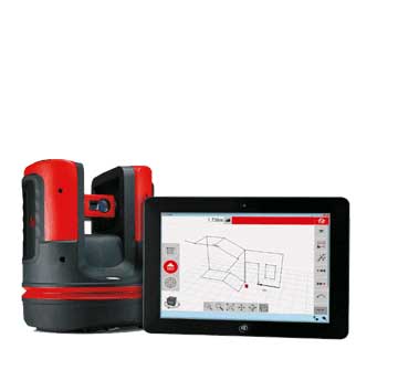
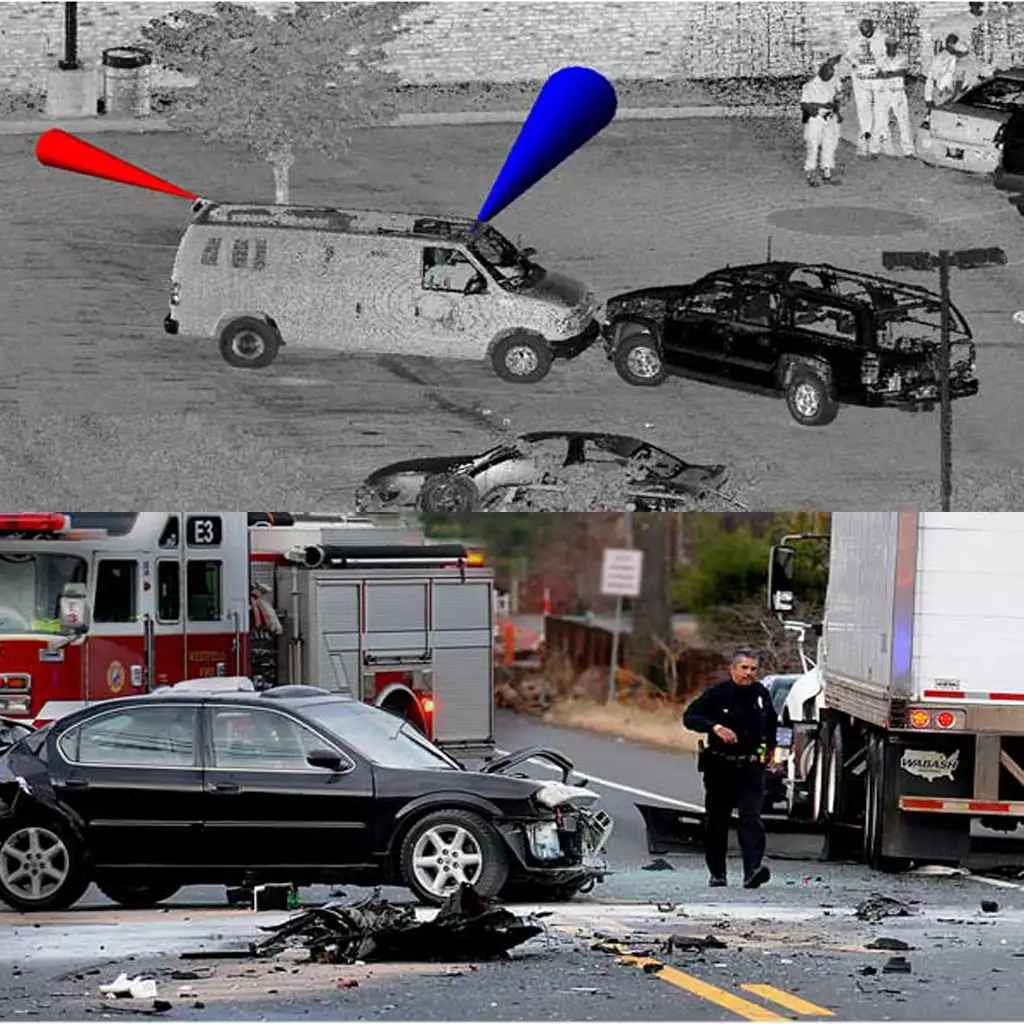
Leica Map360, part of the Leica Geosystems IMS Incident Mapping Suite, is a crash and crime drawing software solution that lets users import, process, analyse, visualise and create court ready deliverables. Map360 provides crash and crime reconstructionist with multiple user interfaces for all skill levels and easy to use tools to visually communicate a scene and critical evidence. Import scenes of any size into Map360 from a wide range of sensors such as laser scanners, total stations and GNSS, to produce accurate 2D or 3D diagrams and animations.
Map360 continues to evolve with support for the latest mapping technologies; from both Leica Geosystems and third-party provides as well as new tools to create court ready diagrams quickly and easily. Map360 also offers two extensions for more extensive final deliverables.
Featured Highlights
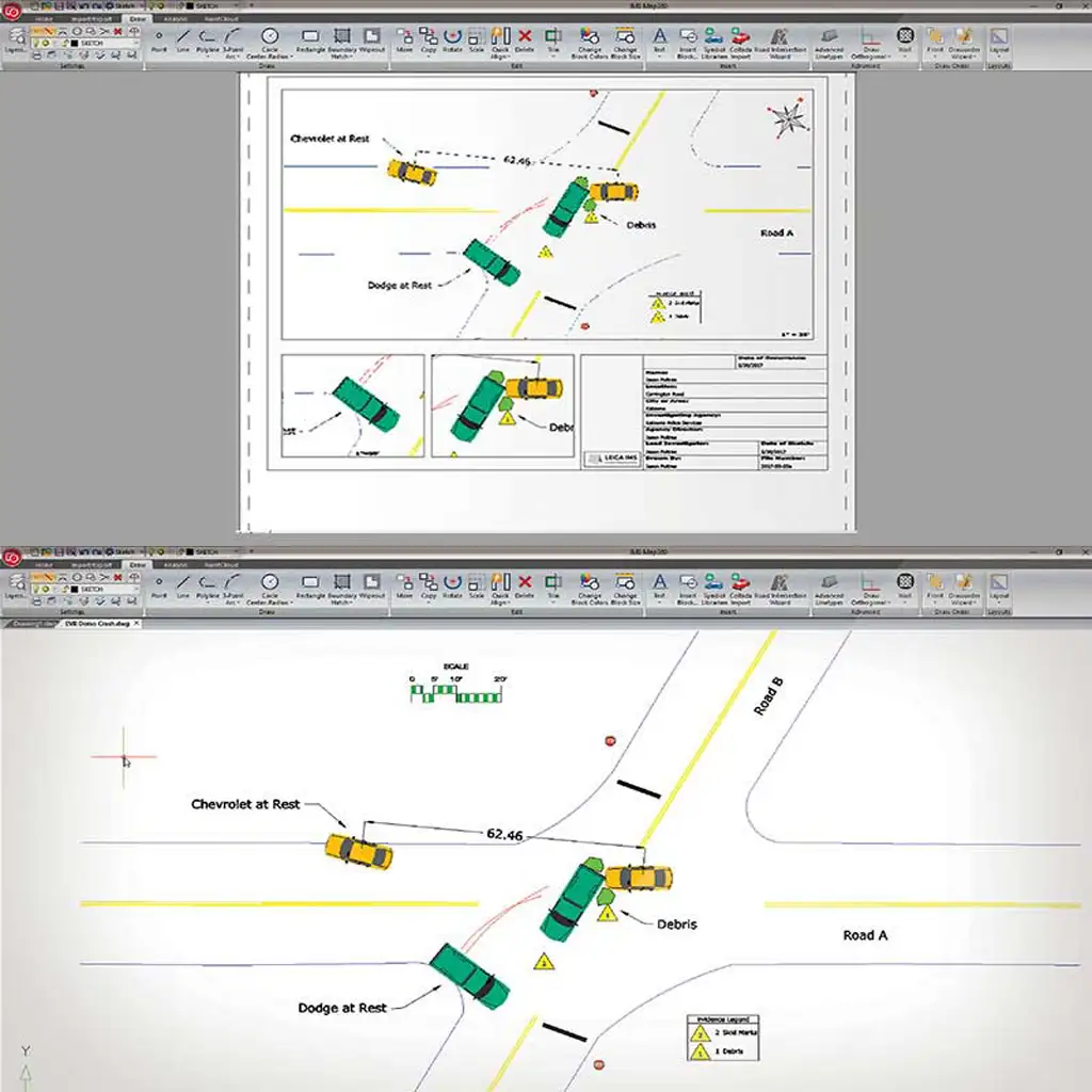
| Easy Scene-To-Map Productivity
Turn your data into a diagram with ease by using scene mapping software such as Evidence Recorder or Leica Captivate. With Map360, the map you create at the scene can be turned into a ready-to-print finished diagram in minutes. |
Witness Viewpoint Analysis
Corroborating or disproving witness statements about what they could or couldn’t see during the incident is simple using Witness Viewpoint. Just pick a point, add a viewpoint at a specific height above that, and take a look around for yourself in 3D view mode. |
| Sophisticated Crash and Crime Scene Reconstruction Tools
Calculators are included for a variety of crash reconstruction formulae; speed, deceleration factor, kinetic energy, momentum, kinematics, and more. Also included is an updated vehicle specification database and a powerful bullet path reconstruction tool that uses a best fit solution to establish accurate trajectories. |
Support for all of your Measuring Tools and Methods
Flexibility and multi-sensor support makes Map360 both productive and scalable to your agency’s needs as they change and grow. Starting with manual scene measurement entry, all the way up to advanced mobile mapping systems (and everything in between!), Map360 provides a common user experience for a wide range of sensors, including support for total stations, laser scanning, GNSS, MultiStations, Unmanned Aircraft Systems, Photogrammetry, Manual Measurement Data and mobile scanning solutions. |
| The Power of CAD, Simplified
Map360 is the most precise desktop forensic mapping software available in the world and is the only solution that has an industry leading 3D CAD system built-in. The underlying precision of our engineering-grade CAD engine provides you with a solid foundation to your work that is precise, compelling, and irrefutable. |
Audit Log for Evidence Integrity
The CAD points that make up your diagram are stored in a separate, protected database file for security. Any attempt to change point coordinates will result in a warning. Any changes made are noted in the database and can be examined through audit log reporting. |
| Simple Sketch or Advanced Mode, You Decide!
Sometimes you just need to generate a simple 2D scene diagram in a hurry. Our easy-to-use sketch mode is perfect for that. Should your project have more demanding needs, you can switch to advanced mode to give yourself access to the tools you need, when you need them. |
Custom Library
The new Collada importer allows us to bring in many newer and more sophisticated 2D and 3D models and saves into the program allowing you build up your own custom library. |
| Wizard for Creating Finished Diagrams
Interactive templates allow you to easily visualise your printed diagram before you print compelling documents. |
Customisation
Map360 has the ability to easily customise your drawing area and tool bars for maximum productivity. |
کاتالوگ
Leica Map360 brochure
گزارش عملکرد
Leica Map360 Bloodstain Pattern Analysis
MAP360 V 3.1 – (JANUARY 15, 2020)
یادداشت انتشار
نرم افزار نقشه برداری Leica Geosystems IMS
Leica Evidence Recorder
نرم افزار جمع آوری داده ها برای بازسازی صحنه حادثه
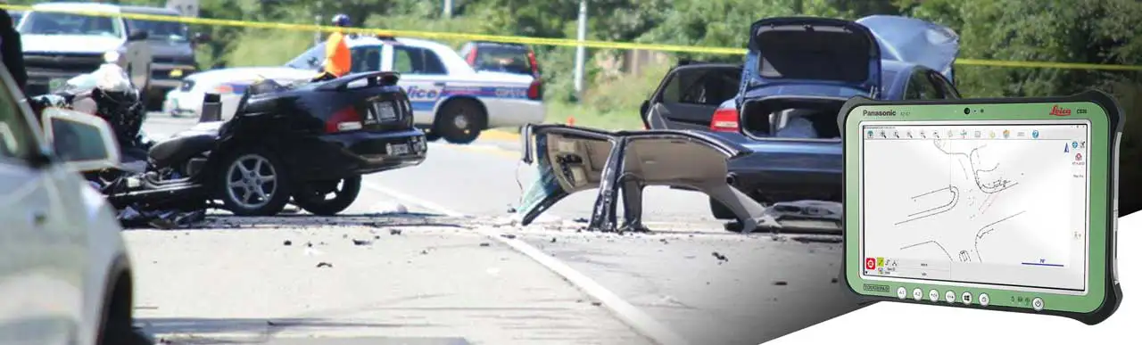
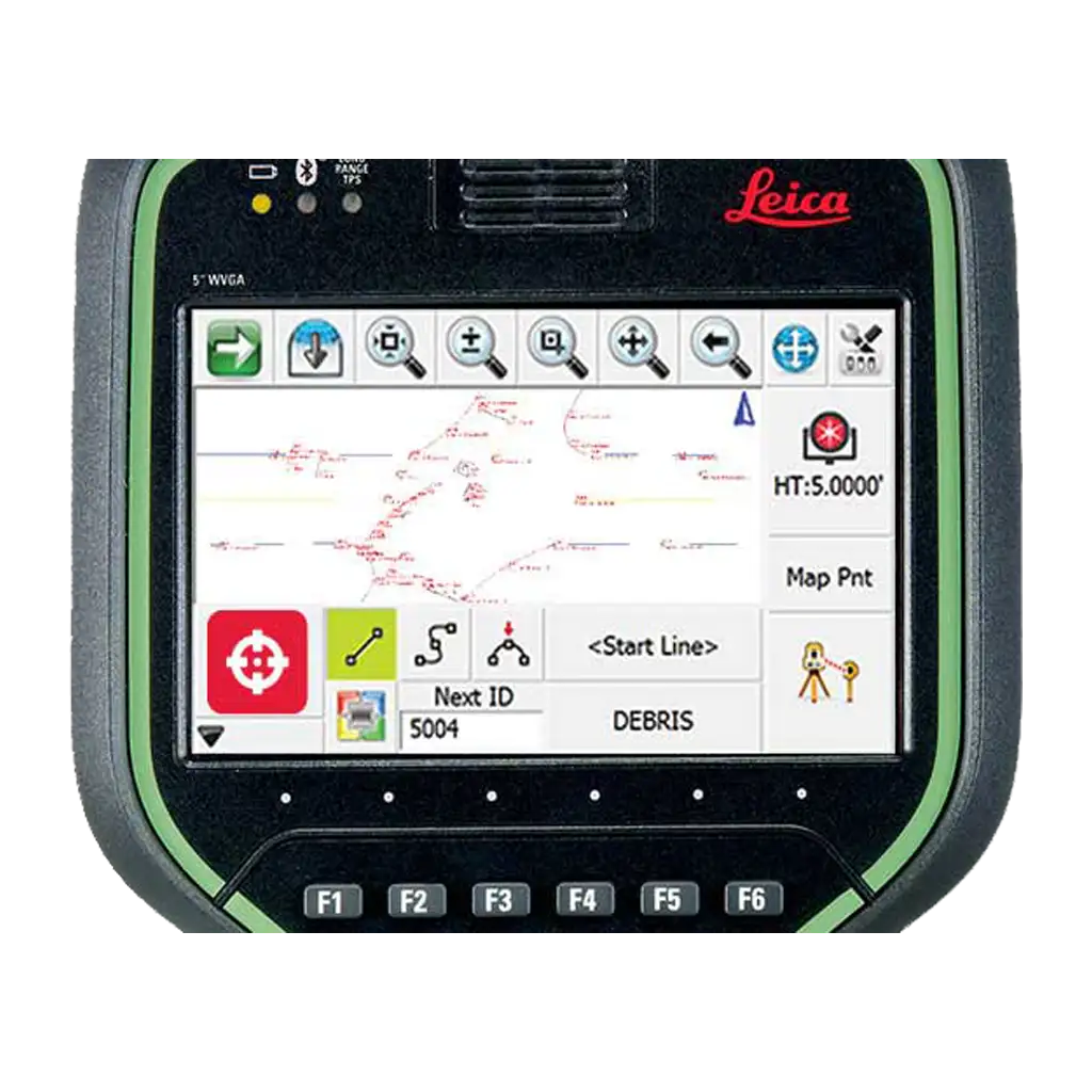
Leica Evidence Recorder, part of the Leica Geosystems IMS Incident Mapping Suite, is the world’s best-selling evidence collection software built specifically for the crash and crime reconstructionist. This software allows users to review their measurements in 2D or 3D and confirm there are no errors or missing points before leaving the scene. Evidence is captured correctly and comprehensively every-time.
Reduce errors. Save time. Eliminate frustration.
Evidence Recorder enables you to identify details graphically, confirm you have everything you need, and rectify any errors or omissions – all before you leave the scene. Why wait until you have loaded your data into your desktop computer to realize critical evidence points have been missed or are incorrect? Evidence Recorder will give you confidence that your evidence data is captured, correct, and comprehensive.
Featured Highlights
| Graphical User Interface
With its industry-leading user interface, you won’t believe the power, clarity, and ease of use Evidence Recorder can bring to mobile devices and tablets. Crisp, high-definition graphics, smooth panning and zooming and logically organised menus. |
Advanced Setup and Measurement Options
Unparalleled measuring and calculation options are all quickly accessible with an intuitive menu structure –built specifically around feedback from users like you. Also perform offsets, easy 3-Point resection (reposition) and useful quick measurement and calculation tools. |
| Calculation and Surface Modeling
Create real-time 3D surface models to visualise complex scenes. |
Written and Audio Notes
Easily append audio notes to shots. Play them back within Evidence Recorder, or retrieve them when mapping with Map360. |
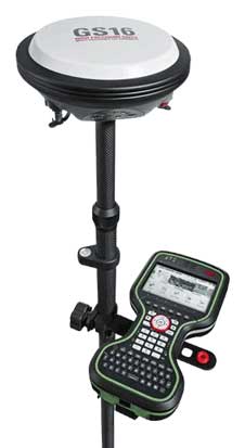
| Total Station and High-Precision GPS Support
Evidence Recorder supports all common total stations, many of which can be controlled right from the Evidence Recorder interface. A wide range of RTK GPS receivers are also supported. |
Smart Toolbars
Regular-use items are a single click away. Menus are context sensitive: If you click a point in your diagram, you get all the menu items relevant to that point. |
| AutoMAP Library and Description Lists
Customisable AutoMAP libraries automatically synchronize to Map360. Also allows export/import formats: ASCII, DXF, XML or Shape files. |
Data Security
No need for constant saving – each measurement is automatically saved. You also have the option to encrypt the working file. |
| Active Lines List
Start as many lines as you like – the active lines list will keep track of any line in progress, and allow you to easily jump back and forth are also supported. |
Video Points Scanning
An exclusive feature in Evidence Recorder, allowing you to visually define a scan area through the total station on-board cameras and automatically generate point cloud data with your Leica MS50 or Leica MS50. |
کاتالوگ
Leica Evidence Recorder brochure
EVIDENCE RECORDER V 11.4 – (APRIL 24, 2019)
یادداشت انتشار
نرم افزار نقشه برداری Leica Geosystems IMS
مشخصات فنی : Leica Geosystems IMS
| برند | |
|---|---|
| کشور سازنده | سوئیس |
برای نوشتن دیدگاه باید وارد بشوید.

دیدگاهی ثبت نشده.